Written by Janine Owen
When it comes to taking a vacation, not everyone thinks “how can I map this?!”
However, as a geographer, mapping is always on my mind and vacations are therefore a great opportunity to bust out my trusty black and yellow handheld GPS unit (affectionately known as Bumblebee) and collect some data.
In 2014, I took a trip to Bali, Indonesia with my husband Richard. Not only was it an excellent retreat for the both of us, it was a brilliant opportunity for me to collect some field data that I could play around with later. Fast forward to the summer of 2020, and I – like so many Canadians – am dreaming of a future vacation and reminiscing over past trips. Now is the perfect time to dig into my Bali data and have some fun.
Although the COVID-19 pandemic has put all of our travel plans on hold, let’s take a trip down memory lane together (GIS-style) as I share two fun things that you can do with GPS data.
Creating an ArcGIS Online elevation app
To get around Bali, my husband and I rented a van from a local company. With our accommodations pre-booked all around the island for various dates, we jumped in the van, buckled up, and hit the road to explore the beautiful landscape.
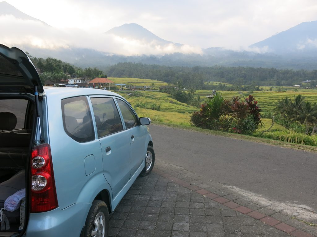
Our rental van and one of the many beautiful views we encountered on our Bali road trip adventure.
We met countless kind, wonderful people, and we learned a lot about the history and culture of Bali as we journeyed from place to place. We visited beaches, mountains, and everything in between. It was a truly unforgettable road trip!
To document our travels up and down the mountainous terrain, I created an elevation profile app using my GPS data and ArcGIS Online. The easy-to-use app generated an interactive elevation profile for each leg of our journey (individual legs were each recorded as a separate GPS track line by Bumblebee).
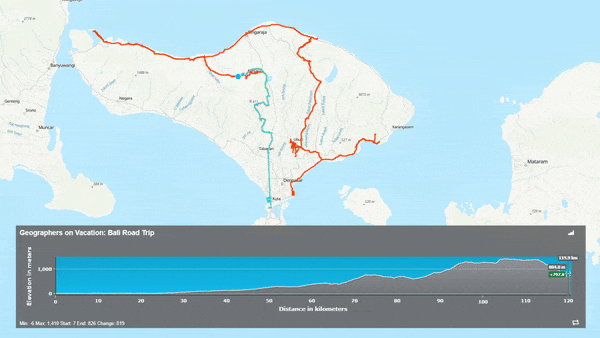
Animation showing one elevation profile generated in the ArcGIS Online elevation app.
Besides being useful for documenting our road trip, the location, elevation and speed data collected in our GPS tracks could also be used for other things, including:
- Correlating wildlife or vegetation observations with changes in elevation
- Identifying very steep sections of road (…and there were plenty of them!)
GPS tracks also act like breadcrumbs in unfamiliar areas, helping users back-track to their starting point. Bumblebee definitely helped us find our way ‘home’ on more than one occasion in Bali. 😊
Recreating our view of Mt. Batur using viewshed analysis
Of all the places that we visited on the island of Bali, one of the most memorable for me was Mt. Batur (Gunung Batur) – an active volcano located in the Bangli Regency.
We had lunch in a coffee house perched on the rim of the giant volcanic crater (known as a caldera) and I remember that the view from our table gave me the feeling of being on the edge of the world; it was absolutely breathtaking.
But don’t just take my word for it, I quantified that amazing view using GIS!
Specifically, I performed a viewshed analysis in ArcGIS Pro using the coordinates of the coffee house as the observation point to assess the view of Mt. Batur. Check out my results below.
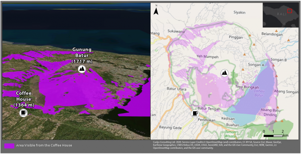
Viewshed analysis results.
Viewshed analyses allow you to determine what areas or features are visible from one or more observation points. The purple areas shown on the map above represent the view of Mt. Batur from our table at the coffee house. The visibility gap directly in front of the coffee house is due to the extremely steep terrain, whereas visibility gaps behind Mt. Batur represent areas where our view was blocked by the mountain itself.
Compare the viewshed analysis results above to the photo shown below – this picture was taken from our table. It’s almost like being there, right?
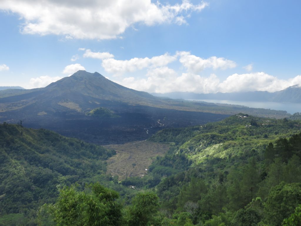
The view of Mt. Batur and the surrounding area as seen from the coffee house.
What I learned
Mapping our vacation data, even years later, really did bring our Bali adventure back to life.
If a picture is worth a thousand words, I say a map must be worth 1001!