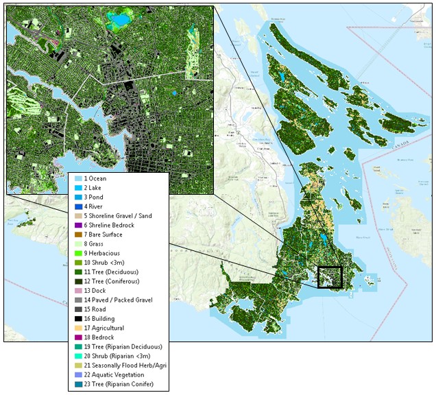
Land Cover Mapping and Analysis in the Capital Regional District
Caslys conducted a series of land cover mapping tasks to update forest canopy cover and impervious surface reporting in the Capital Regional District (CRD). This project is a continuation from previous land cover mapping initiatives completed by Caslys in 1986, 2005 and 2011, which included trends in land cover change, forest canopy cover and impervious surface trends over time per municipal area. Using orthophotos from 2017 and 2019, combined with an enhanced approach that takes advantage of available Provincial LiDAR data, our team was able to discern additional vegetation classes and make significant improvements to precision and accuracy.
We used advanced methods to map riparian potential, accounting for vegetation types, storm water management infrastructure and detailed terrain information. Our updated methodology utilized multi-temporal imagery, allowing our team to more accurately define agricultural areas and develop mapping techniques to highlight tree planting potential while taking into account existing land cover, land use and land ownership parameters. Additionally, the processing of LiDAR point cloud data permitted us to calculate precise tree metrics to define coniferous and deciduous trees with vegetation height, and allowed us to create a GIS point file to serve as the starting point for a formal tree asset management geodatabase.
Deliverables included summaries of percent change in each land cover class, tree canopy cover, and impervious surfaces for the Core Metropolitan Area, plus the Southern Gulf Islands and areas near Port Renfrew. Throughout the project, we maintained strong collaborative efforts with key stakeholders within the CRD to ensure that the enhanced methods and deliverables met a variety of end-use requirements with a method that can be replicated in future to continue monitoring land cover trends in the region.