After years of technical development and internal pilot testing, Caslys Consulting is proud to officially announce our new geospatial service to the remote sensing and GIS world, the Caslys Analysis Ready Data (CARD) Stack!
Assembling terrain data, spatial data, or satellite imagery at the beginning of a project is often a complicated and cost inefficient process. There is a large amount of geoprocessing needed to obtain high-quality data, satellite imagery, and build a suite of useful derivative map layers that meet project requirements. This can be a very time-consuming task, using up more project budget than necessary.
What is CARD Stack?
CARD Stack is a technical resource focused on allowing our customers the ability to easily generate comprehensive spatial datasets. These datasets kick-start both spatial and spectral analyses while also enhancing the visualization of a project site through a simple request submission.
Caslys Consulting has created multiple scripts, tools, and geospatial resources with the goal of making this task easier for our customers. CARD Stack services efficiently streamline data package assembly and delivery for a client in a timely manner. Based on the request, a wide range of raster and vector products are consolidated by our team into a single, user-friendly data package.
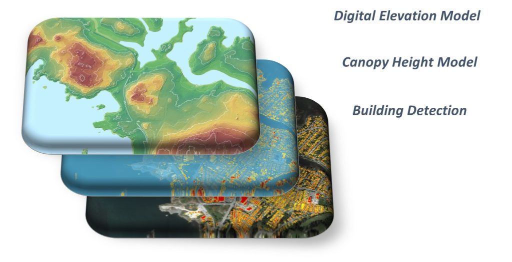
These packages can include:
- Imagery products and spectral derivatives to help inform environmental trends across an area of interest.
- Terrain data in raster formats, projected and stacked (hence the name CARD Stack) for analysis.
- Professional grade vector dataset series that assist in adding context to a user’s project.
- An extensive list of all the data layers and other relevant indices
- Dataset workflow support

Learn more about CARD Stack today!
The Caslys CARD Stack team is excited to help our customers accomplish their geospatial tasks in a fast and efficient manner. For pricing inquiries, product details, and more info on how CARD Stack can help fulfill your project needs, click here or follow the link below.
CARD Stack website: https://www.caslys.ca/cardstack/
About Caslys
For over 20 years, Caslys Consulting Ltd. has taken pride in offering a wide range of high-quality geospatial services for both environmental and natural resource management industries.
Our focus is on interpreting and analyzing data to deliver cost-effective solutions and help our clients make better informed decisions. We specialize in Geographic Information Systems (GIS), remote sensing, information management and application development to meet the needs of both public and private sector clients within Canada and abroad.
As a company, Caslys Consulting combines strong technical skills in our specialized fields with the ability to effectively communicate technical results and complex products to help show our clients how it can be used for meaningful decision making. We also understand the importance of sustainability and take pride in promoting sustainable initiatives and practices to help improve the communities we are working in.
Caslys Consulting Ltd. acknowledges and respect the Lək̓ʷəŋən peoples and W̱SÁNEĆ Nations on whose traditional territory the Caslys office is located. We thank them for their strength and resilience in protecting this land and aspire to uphold our responsibilities according to their example.