Each year, June 21st marks National Indigenous Peoples Day. A time for settler reflection, acknowledgement, and appreciation for the Indigenous Peoples across Canada as we all work towards reconciliation. National Indigeouns Peoples day is one that should be used to embrace First Nations, Inuit and Métis peoples by learning, unlearning, engaging and reflecting. Our Caslys team has the privilege and honour to work and live across the Coast Salish, Kwakwaka’wakw and Moh’kinsstis Regions. Specifically, the Nations of: Caslys recognizes these Nations’ stewardship on these lands since time immemorial. We respect the on-going and historical role these Nations have in political, social, environmental and other activities across these jurisdictions. In the spirit of National Indigenous Peoples Day, our team at Caslys would like to share some resources provided by the W̱SÁNEĆ Nations leadership council whose traditional territory the Caslys office is located on. Settlers and others who are interested in allyship with W̱SÁNEĆ people will find these resources below as a great place to support the journey to reconciliation. The listed steps are in a suggested order for those at the beginning of this journey: Below are some online resources that can act as continuing steps towards allyship and reconciliation. Cultural stories, traditional maps, and local council sites are all listed here: Mapping resources https://www.bcafn.ca/first-nations-bc/interactive-map https://www.whose.land/en/ https://native-land.ca/ Podcasts https://www.denetalk.ca/about https://indigenouspodcast.trubox.ca https://forvi.ca/project/indigenous-voices-vancouver-island-podcast/ Local Councils https://wsanec.com/ https://songheesnation.ca/ https://cowichantribes.com/ https://wewaikai.com/ https://tsuutina.com/ About Caslys For over 20 years, Caslys Consulting Ltd. has taken pride in offering a wide range of high-quality geospatial services for both environmental and natural resource management industries. Our focus is on interpreting and analyzing data to deliver cost-effective solutions and help our clients make better informed decisions. We specialize in Geographic Information Systems (GIS), remote sensing, information management and application development to meet the needs of both public and private sector clients […]
Continue readingMonthly Archives: June 2024
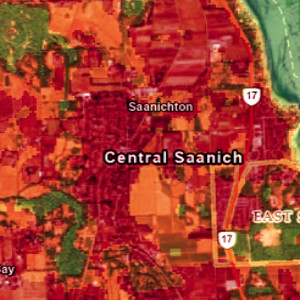
Analyzing Summer Heat Domes using Land Surface Temperature
With summer approaching and anticipation for rising temperatures growing, our team at Caslys reflected on some of the past heat waves in recent memory and dove into some current extreme temperatures being experienced elsewhere in the world. Analysis Completed using CARD Stack Services June of 2021 stood out to many of us in the Victoria region, with record breaking high temperatures causing city wide stress and even pushing businesses to close due to both health and technical issues. Leveraging our CARD Stack services, the Caslys team accessed analysis-ready datasets to further investigate the 2021 heat dome experienced across southern Vancouver Island. Our approach focused on Land Surface Temperatures (LST) as a key parameter. LST differs from classic weather report temperatures, also know as atmospheric (air) temperatures. It is a measurement of ground or surface temperature to the touch, and is an effective weather index that shows variability for studies at regional and global scales. While weather stations and local sensors can provide temperature data, remotely sensed imagery data has proven to be a great source of accurate temperature distributions at high spatial and/or temporal resolutions¹. After acquiring 10 years of Landsat 8 imagery over multiple June dates for the CRD, the LST was calculated and used in this case study to create strong visual indicators of surface temperature extremes. The June 21st, 2021 image showcases the abnormally high surface temperatures experienced across the Saanich Peninsula, reaching upwards of 40oC. This is more than double the expected June temperature high, which between 2000 and 2024, is about 17oC according to historical data. Areas with forest and tall vegetation were much cooler relative to developed areas with concrete or pavement, causing extreme urban heat island effects. Heat Waves Around the World Parts of Mexico and India recently experienced similar abnormal heat waves […]
Continue reading