With summer approaching and anticipation for rising temperatures growing, our team at Caslys reflected on some of the past heat waves in recent memory and dove into some current extreme temperatures being experienced elsewhere in the world.
Analysis Completed using CARD Stack Services
June of 2021 stood out to many of us in the Victoria region, with record breaking high temperatures causing city wide stress and even pushing businesses to close due to both health and technical issues. Leveraging our CARD Stack services, the Caslys team accessed analysis-ready datasets to further investigate the 2021 heat dome experienced across southern Vancouver Island.
Our approach focused on Land Surface Temperatures (LST) as a key parameter. LST differs from classic weather report temperatures, also know as atmospheric (air) temperatures. It is a measurement of ground or surface temperature to the touch, and is an effective weather index that shows variability for studies at regional and global scales. While weather stations and local sensors can provide temperature data, remotely sensed imagery data has proven to be a great source of accurate temperature distributions at high spatial and/or temporal resolutions¹.
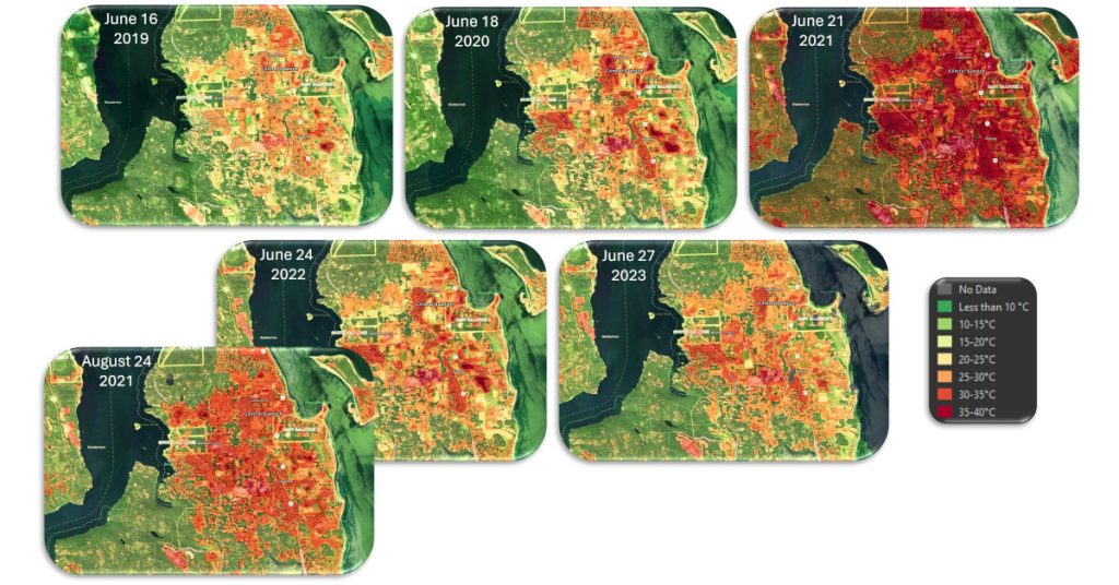
After acquiring 10 years of Landsat 8 imagery over multiple June dates for the CRD, the LST was calculated and used in this case study to create strong visual indicators of surface temperature extremes. The June 21st, 2021 image showcases the abnormally high surface temperatures experienced across the Saanich Peninsula, reaching upwards of 40oC. This is more than double the expected June temperature high, which between 2000 and 2024, is about 17oC according to historical data. Areas with forest and tall vegetation were much cooler relative to developed areas with concrete or pavement, causing extreme urban heat island effects.
Heat Waves Around the World
Parts of Mexico and India recently experienced similar abnormal heat waves in late May and early June 2024. LST for Mexicali reached 43oC, and in Delhi, surpassed 50oC, sadly resulting in many causalities and extreme health concerns for locals in both areas. These high spring temperatures can also be problematic for regions that rely on agricultural as a driving force for their economy. The heat and resulting drought require more water and energy from farmers to maintain fruit and vegetable quantities for local and global markets.
Tips to Stay Safe During Heat Events
As the summer months get closer for 2024 and the temperature rises, it is recommended to have a plan to stay safe if temperatures get well above normal. For more information on how to stay safe this summer, visit:
www.crd.bc.ca/prepare-yourself/hazards-in-our-region/extreme-heat
About Caslys
For over 20 years, Caslys Consulting Ltd. has taken pride in offering a wide range of high-quality geospatial services for both environmental and natural resource management industries.
Our focus is on interpreting and analyzing data to deliver cost-effective solutions and help our clients make better informed decisions. We specialize in Geographic Information Systems (GIS), remote sensing, information management and application development to meet the needs of both public and private sector clients within Canada and abroad.
As a company, Caslys Consulting combines strong technical skills in our specialized fields with the ability to effectively communicate technical results and complex products to help show our clients how it can be used for meaningful decision making. We also understand the importance of sustainability and take pride in promoting sustainable initiatives and practices to help improve the communities we are working in.
Caslys Consulting Ltd. acknowledges and respect the Lək̓ʷəŋən peoples and W̱SÁNEĆ Nations on whose traditional territory the Caslys office is located. We thank them for their strength and resilience in protecting this land and aspire to uphold our responsibilities according to their example.
References: H. Shwetha and D. N. Kumar, “Predicition of high spatio-temporal resolution land surface temperature under cloudy conditions using microwave vegetation index and ANN” ISPRS J. Photogramm, Remote Sens., 117 40 -55 (2016). https://doi.org/10.1016/j.isprsjprs.2016.03.011 IRSEE9 0924-2716