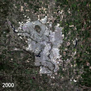
Calgary, Alberta is once again one of the fastest growing cities in Canada. With a constantly evolving city skyline, and growing community boundaries, our team at Caslys thought it would be interesting to apply our landscape change tools to see what’s been happening. We utilized Landsat satellite imagery and our new Caslys Analysis Ready Data (CARD) Stack processes, to explore the change in landscape across Calgary over the past 20+ years. The results are included in the article below, highlighting the overall expansion that the city is experiencing. With a strong job market and diverse amenities, Calgary is an attractive place to be and is recently one of the fastest growing metropolitan areas in Canada. Between 2022 and 2023, Calgary experienced the largest population increase in the country, surpassing 1.6 million people. We applied a few analysis methods to see what the growth distribution looks like on the landscape. There have been some significant growth spurts over the last couple decades. While suburban growth into the agricultural outskirts remains a common theme as you can see in the animation below, there are also new communal green spaces within the city. Development Milestones In 2013, Calgary moved forward with highway construction in two areas, developing the “Ring Road”. It’s part of a larger east-west/north-south trade corridor, and enhances the city’s accessibility. Improved transportation infrastructure helps connect the four quadrants of the city and links the new communities that are developing on the outskirts of Calgary. A projected 17 new neighbourhoods surrounding the city within the 2024 Area Structure Plans and Citywide Growth Strategy were announced. Within the downtown area of Calgary, further transportation development continues to push forward with additional light rail transit lines (LRT) being added to help commuters throughout the city. Olympic Plaza and the Eau Claire Market area […]
Continue reading