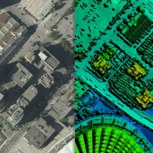
Over the past several years, the Province of British Columbia has made significant investments in LiDAR and has now released provincial LiDAR collections known as LidarBC under the Open Government License. This data is now freely available for anyone to download and use via the LidarBC Open Data Portal. Until recently, British Columbia was without publicly available LiDAR data. This limited access, combined with large file sizes, greatly limited the potential of many in the GIS world to conduct research using this rich data source. The LidarBC program has taken the LiDAR point cloud data from large areas and divided them into smaller, more manageable blocks of data, resulting in file sizes that will not overload browsers. To that end, the Portal uses a provincial map divided by tiles that allows users to locate the data they want precisely, without obtaining necessary excess data. This new tool, developed by Caslys Consulting, also contains a user-friendly interactive guide that shares valuable information on the step-by-step processes needed to use LidarBC’s Open LiDAR Data Portal. What is LiDAR? LiDAR (Light Detection And Ranging) is a uniquely accurate method for elevation acquisition, acting as an active remote sensing system that produces its own energy for acquisition of information. These LiDAR systems are made up of a laser, scanner and GNSS (GPS) receiver that are mounted onto an aircraft. The systems transmit short, high-frequency wavelengths of light to a surface, then record the time of flight and intensity of the back scatter returned to the sensor that make up a point cloud data set. The high spatial resolution of the resulting surface models allows the differentiation of many fine terrain features in both urban and natural environments. The Province of British Columbia now has this powerful active remote sensing system of LiDAR point cloud and derivative data […]
Continue reading