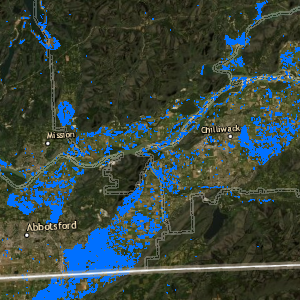
As the rainy season begins to unfold throughout the Pacific Northwest, the southern portion of British Columbia saw a historic atmospheric river condition that brought with it high volumes of precipitation and extensive flooding. The impacts to communities, transportation, agricultural and human life were unprecedented – triggering a state of emergency for many jurisdictions. In response to this natural disaster, Caslys has used publicly available satellite imagery (both Sentinel-1 RADAR images and Sentinel-2 optical imagery from the European Space Agency) to rapidly assess flood conditions in both the Fraser Valley, areas around the communities of Merritt, Princeton and the southern portion of Vancouver Island. Cloud penetrating RADAR imagery from before the flooding was compared to images taken on November 16th when the flood was near its peak. The results show very clearly where the land is inundated with floodwaters. Caslys then incorporated the Land Cover Atlas for Urban and Rural BC dataset that we developed for the Ministry of Forests, Lands, Natural Resource Operations and Rural Development to assess the flooding with respect to land use types such as agricultural fields, roads and parklands. The dataset covers much of the Fraser Valley Regional District (FVRD) plus Langley and Maple Ridge within Metro Vancouver Region. The most extensive flooding was found with over 1205 hectares of agricultural lands flooded in Abbotsford, 257 hectares in Chilliwack and 296 hectares in other municipalities. Major flooding also occurred across more than 10 kilometres of road surface. Caslys has provided the results and methods of our analysis to geomatics professionals at Emergency Management BC which is playing a key role in providing data and resources to assist in the flood response. We hope that our work augments the detailed monitoring efforts that they are implementing to assist in key impacted areas of the province. Our […]
Continue readingTag Archives: British Columbia
LidarBC: A New Open Data Portal for LiDAR
Over the past several years, the Province of British Columbia has made significant investments in LiDAR and has now released provincial LiDAR collections known as LidarBC under the Open Government License. This data is now freely available for anyone to download and use via the LidarBC Open Data Portal. Until recently, British Columbia was without publicly available LiDAR data. This limited access, combined with large file sizes, greatly limited the potential of many in the GIS world to conduct research using this rich data source. The LidarBC program has taken the LiDAR point cloud data from large areas and divided them into smaller, more manageable blocks of data, resulting in file sizes that will not overload browsers. To that end, the Portal uses a provincial map divided by tiles that allows users to locate the data they want precisely, without obtaining necessary excess data. This new tool, developed by Caslys Consulting, also contains a user-friendly interactive guide that shares valuable information on the step-by-step processes needed to use LidarBC’s Open LiDAR Data Portal. What is LiDAR? LiDAR (Light Detection And Ranging) is a uniquely accurate method for elevation acquisition, acting as an active remote sensing system that produces its own energy for acquisition of information. These LiDAR systems are made up of a laser, scanner and GNSS (GPS) receiver that are mounted onto an aircraft. The systems transmit short, high-frequency wavelengths of light to a surface, then record the time of flight and intensity of the back scatter returned to the sensor that make up a point cloud data set. The high spatial resolution of the resulting surface models allows the differentiation of many fine terrain features in both urban and natural environments. The Province of British Columbia now has this powerful active remote sensing system of LiDAR point cloud and derivative data […]
Continue reading